Nowhere in the United Kingdom is more than 114 km from the coast, yet the sea is low and flat, the land gets in the way and the Earth curves. From how much of the country can you actually see it? For each of the UK's 244,595 squares of 1 km I stood an imaginary person in the middle, eyes 1.7 m above the bare ground, and traced a sight line every degree, out to 50 km, over the hills and valleys.
Read every figure as an upper bound: bare terrain, with no buildings or trees. The headline is resolution-sensitive: finer terrain (about 88 m) lowers it by up to 7.3 points in the test areas. "Sea" here includes tidal estuaries and sea lochs.
01 · The mapA quarter of the land
From 64,277 squares, 26.3% of the land, the sea is in view. Scotland, with its long ragged coast, mountains and sea lochs, sees it from 41% of its land, Wales from 34%, Northern Ireland from 22% and England, with its broad lowland middle, from only 16%. Where there is a view the nearest visible sea is typically about 6 km away, and it is usually a slice: the median square with a view sees sea across 14% of the horizon. Switch the map to "Share of horizon" to find the 2,789 squares with sea across more than half of it, like Land's End.
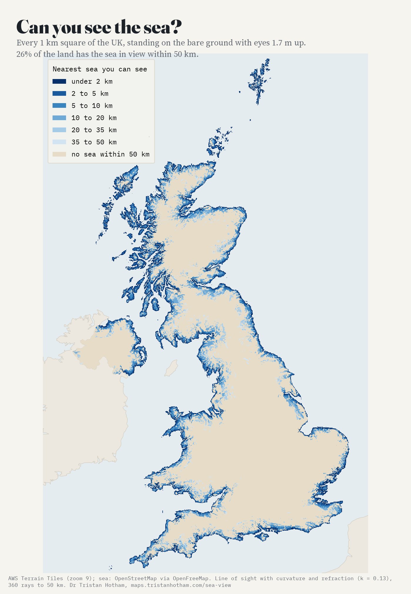
Distance to the nearest sea in view from every 1 km square, eyes 1.7 m.
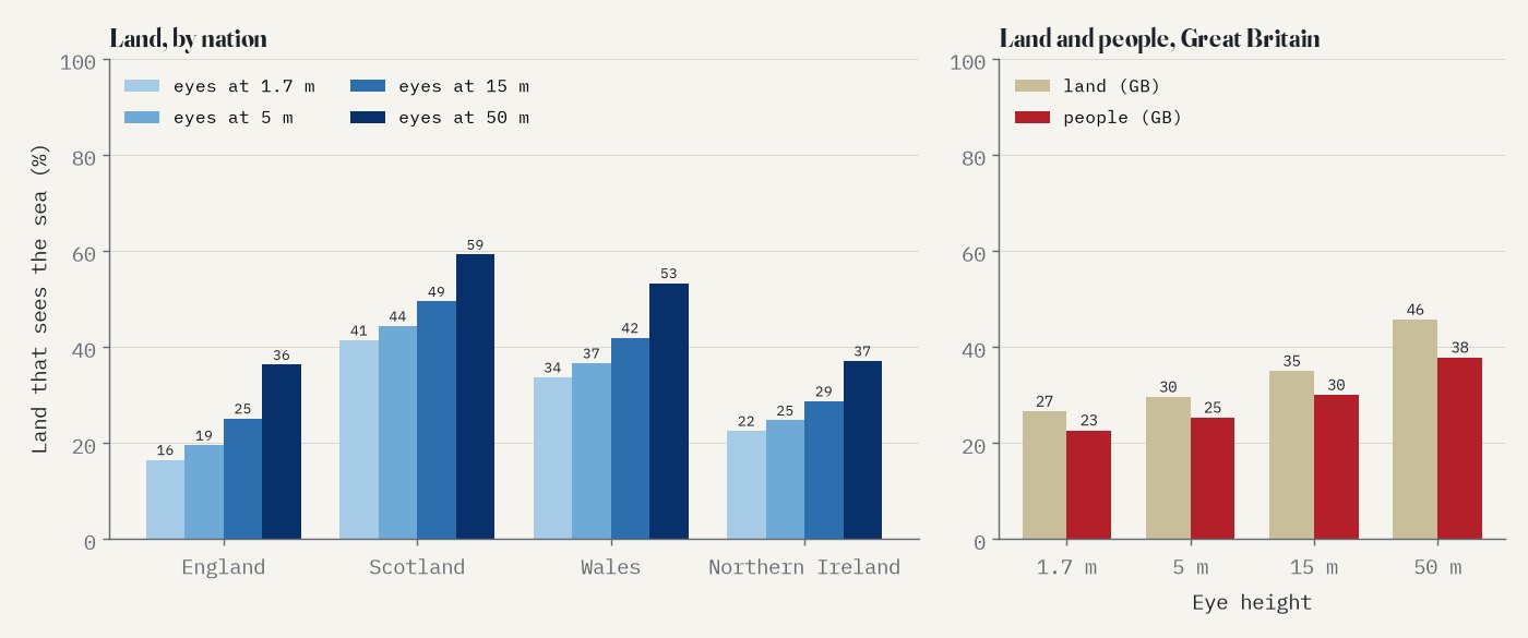
Land with a sea view by nation and eye height (left); land and people in Great Britain (right).
02 · InlandHow far the sea stays in view
Right on the coast nearly every square sees the sea (98% within a kilometre), but 7% of squares within 2 km of it do not, behind dunes, cliffs or the slope of the land. Inland, height decides. On ground below 50 m half the squares have lost the sea by about 3 km from the coast; on ground of 150 to 300 m the half-way point is about 9 km in, and higher ground, mostly mountain country where the next peak hides the sea, does no better at that mark, though its tops see the sea more often further in: 80 squares above 300 m see it from 40 km or more inland. Raise your eyes with the slider: from an upstairs window 29% of the land sees the sea, from a fifth floor 35%, from a 50 m tower 45%.
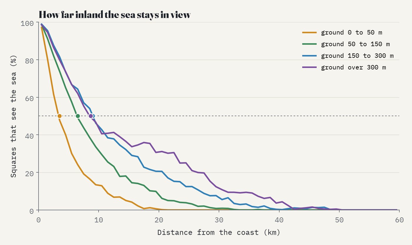
Share of squares with a sea view by distance from the coast and ground height.
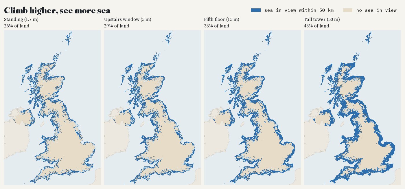
Land with the sea in view at four eye heights.
03 · Inland EnglandThe sea-view desert
The square farthest from any square with a sea view is near Donington le Heath in Leicestershire, 94 km from one. The square farthest from the coast itself is 114 km from it, near Akeley. Most people in Great Britain live in lowland towns, many inland: 23% live at a settlement point where the terrain allows a sea view, 25% if they look from an upstairs window.
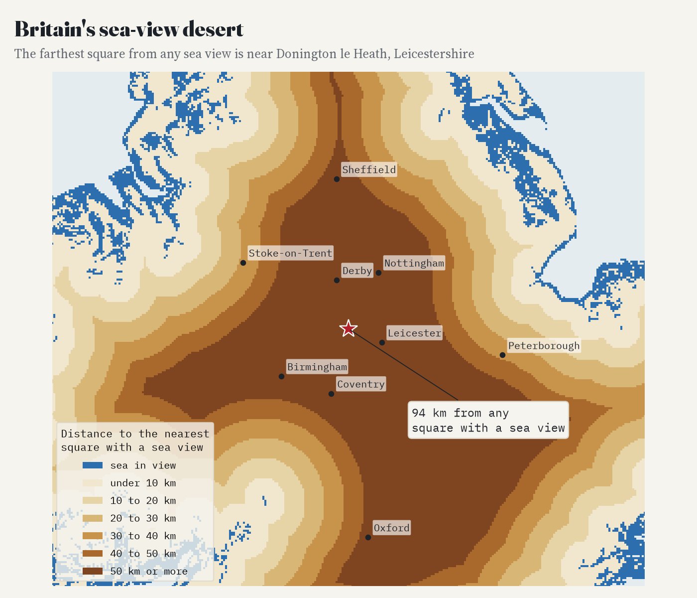
Distance to the nearest square with a sea view, central England.
04 · CheckingHills with a famous view
I checked the model against 10 viewpoints whose sea view is written down (blue and red dots on the map). It finds the sea from 8 at the height of the terrain data and 9 at their real summit heights, which the coarse terrain rounds down. From Pendle Hill at its real 557 m the model sees the Lancashire coast about 40 km away, as George Fox did in 1652: "I saw the sea bordering upon Lancashire". It never finds the "Bristol Channel" view from Worcestershire Beacon, even out to 100 km.
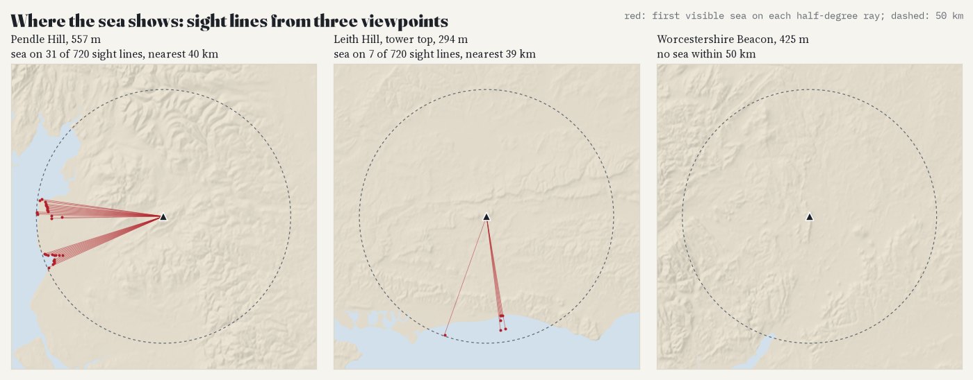
Sight lines every half degree from three viewpoints, ending at the first visible sea.
05 · How I did thisSight lines over bare ground
Land and sea. Heights from the open AWS Terrain Tiles at zoom 9 (about 175 m); the sea is OpenStreetMap's coastline, which runs up tidal estuaries and sea lochs, from OpenFreeMap tiles. Sight lines. From the centre of every Ordnance Survey 1 km square in Great Britain and Irish Grid square in Northern Ireland, a line every degree, in steps of about 90 m, out to 50 km. A point of sea is visible if it shows above everything nearer along the line, allowing for the curve of the Earth and standard refraction of light near the ground (k = 0.13). The plan, with every check, was written before the first result.
Checks. Looking 25 or 100 km out, no refraction or strong refraction, leaving out estuaries and narrow sea lochs, needing the sea on at least three sight lines, twice as many sight lines, four points per square, sharper terrain (about 88 m) and random height errors: across all of these the share of land with a sea view stays between 22% and 27%. Sharper terrain lowers it most: with heights every 88 m the share falls in all four test areas, by up to 7.3 points (about 11% of its value overall), so the headline is resolution-sensitive and, if anything, generous.
What this cannot say. Every figure is an upper bound. The terrain has no buildings, trees or hedges, which hide the sea from many streets: the map shows where the land itself allows a view on a clear day. "Sea" includes tidal estuaries and sea lochs, as in OpenStreetMap's coastline. The coarse terrain rounds off summits and fills narrow valleys, and the answer can change within a square. Haze often hides sea far away. Tides move the water's edge by hundreds of metres in places. People are placed at one Wikidata point per town or village, weighted by 2011 Census constituency populations.
Sources and licences
- Terrain: AWS Terrain Tiles (Mapzen and Tilezen; sources and attribution: SRTM, GMTED2010, ETOPO1 and others).
- Sea: © OpenStreetMap contributors (ODbL), via OpenFreeMap vector tiles, release 20261101_080013_pt.
- Settlements: Wikidata (CC0). Population: 2011 Census by 2010 Westminster constituency (ONS, OGL v3.0). Counties: ONS (OGL v3.0). Context outlines: Natural Earth.
- Viewpoints: Wikipedia, National Trust, South Downs National Park Authority, Pendle Radicals, Cornwall Guide, Wikishire, UKHillwalking, MountainViews (quotations in data/validation.csv).
- Base map: OpenFreeMap Positron (OpenStreetMap, ODbL). MapLibre GL JS 4.7.1 (BSD 3-Clause).
- Sea-view data derived from OpenStreetMap are under the ODbL; text and figures CC BY 4.0; code MIT.