Some beaches give you the whole show: the Sun sliding down into an empty sea. Others hide it behind a headland, an island or the far side of a bay. On most of the east coast the sea sunset never comes, but the sunrise does. Which beaches in Britain and Ireland have a sea sunset, or a sea sunrise, and on which days of the year? I traced the Sun's path from 1,717 named beaches to find out.
01 · The mapSunset coasts and sunrise coasts
Most beaches get one or the other, and a fifth get neither: 21% of beaches face a bay, an estuary or a firth where land closes every view of the horizon at sunset and sunrise. 38% get a sea sunset but never a sea sunrise, and 32% the reverse. Wales faces the sunset (67% of its beaches), the east coasts of England and Ireland the sunrise: Longsands at Tynemouth, Killiney in Dublin and 15 beaches in Wexford and 14 in Wicklow see the Sun come up out of the sea on every day of the year.
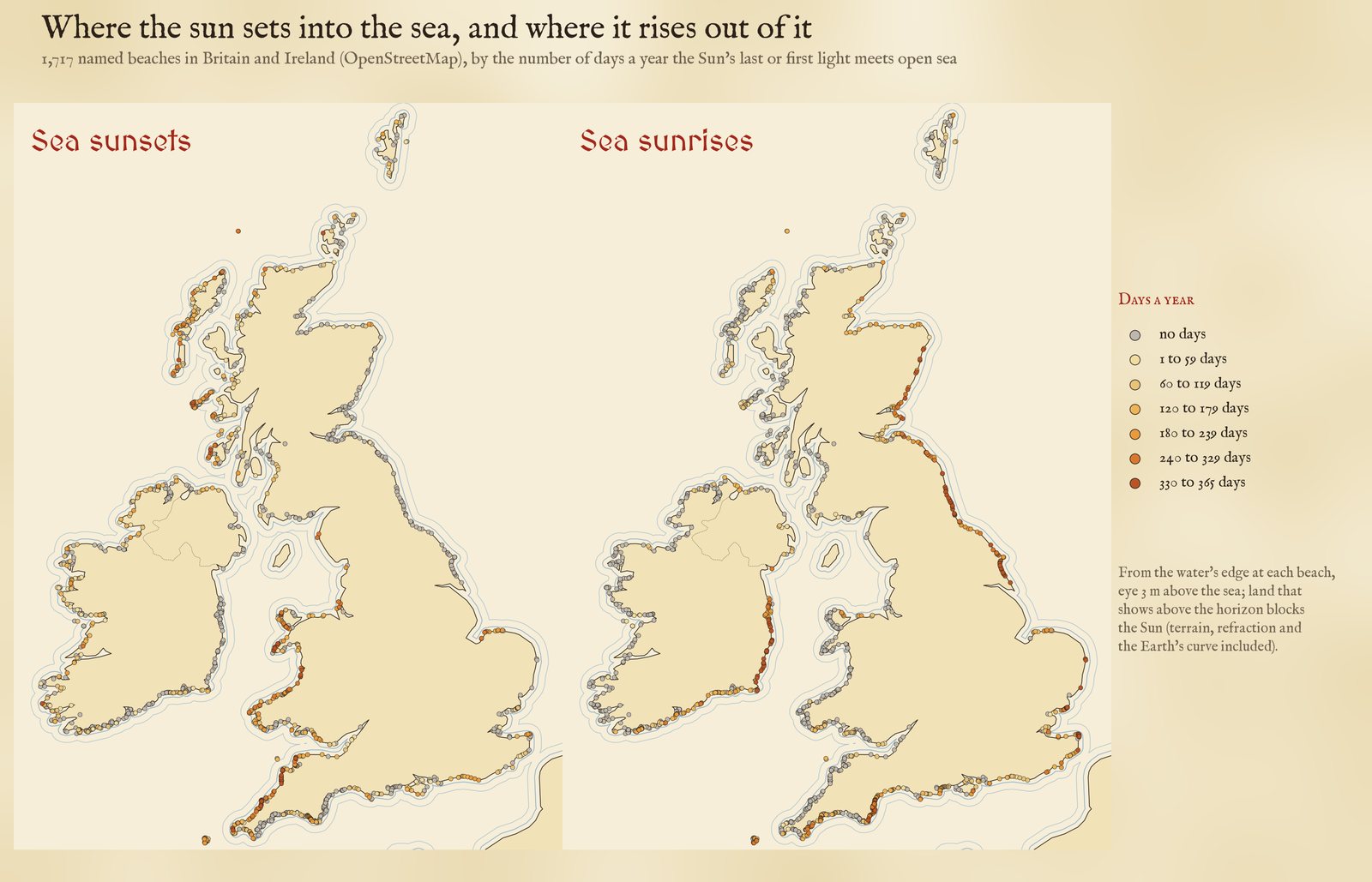
Days a year with a sunset into, and a sunrise out of, open sea.
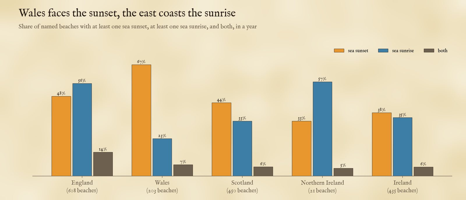
Share of beaches with at least one sea sunset, sea sunrise, or both, by nation.
02 · The yearThe Sun swings along the horizon
At midsummer the Sun sets far to the north-west and rises far to the north-east; at midwinter it sets in the south-west and rises in the south-east. So a beach that faces west may get its sea sunsets only in spring and autumn, with land at both ends of its view. In Cornwall, Sennen Cove looks out on open Atlantic all year round, and Fistral at Newquay gets 304 sea sunsets but none in deep winter, when the Sun goes down behind the headland. On 21 December, 349 beaches have a sea sunset and 405 a sea sunrise; on 21 June only 303 and 231. In winter the Sun rises and sets further south, and more beaches have an open view that way.
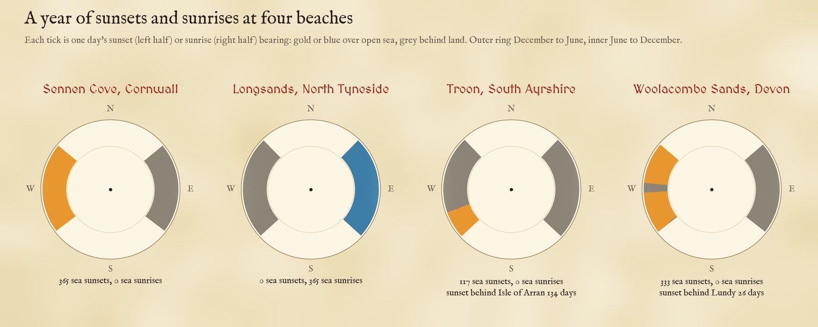
A year of sunset and sunrise bearings at four beaches.
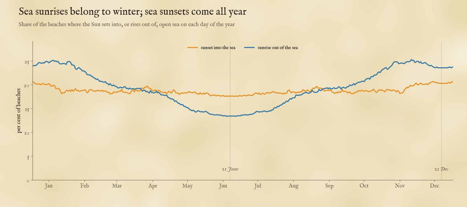
The share of beaches with a sea sunset or sunrise, day by day.
03 · IslandsArran, Lundy and the Isle of Man
Islands take a bite out of the year. From Troon on the Ayrshire coast the Isle of Arran hides the sunset on 134 days, through spring and autumn. Lundy, small and about 30 km out in the Bristol Channel, takes 26 sunsets a year from Woolacombe and 28 from Croyde, around the equinoxes, when the Sun goes down due west. The Isle of Man hides 44 sunsets from Fleswick Bay under St Bees Head, and 73 sunrises from the beaches of County Down. The Isle of Wight and Mull share the record, each standing in the way for 31 beaches: the Isle of Wight for 10 at sunset and 21 at sunrise, along the Solent and the Sussex coast.
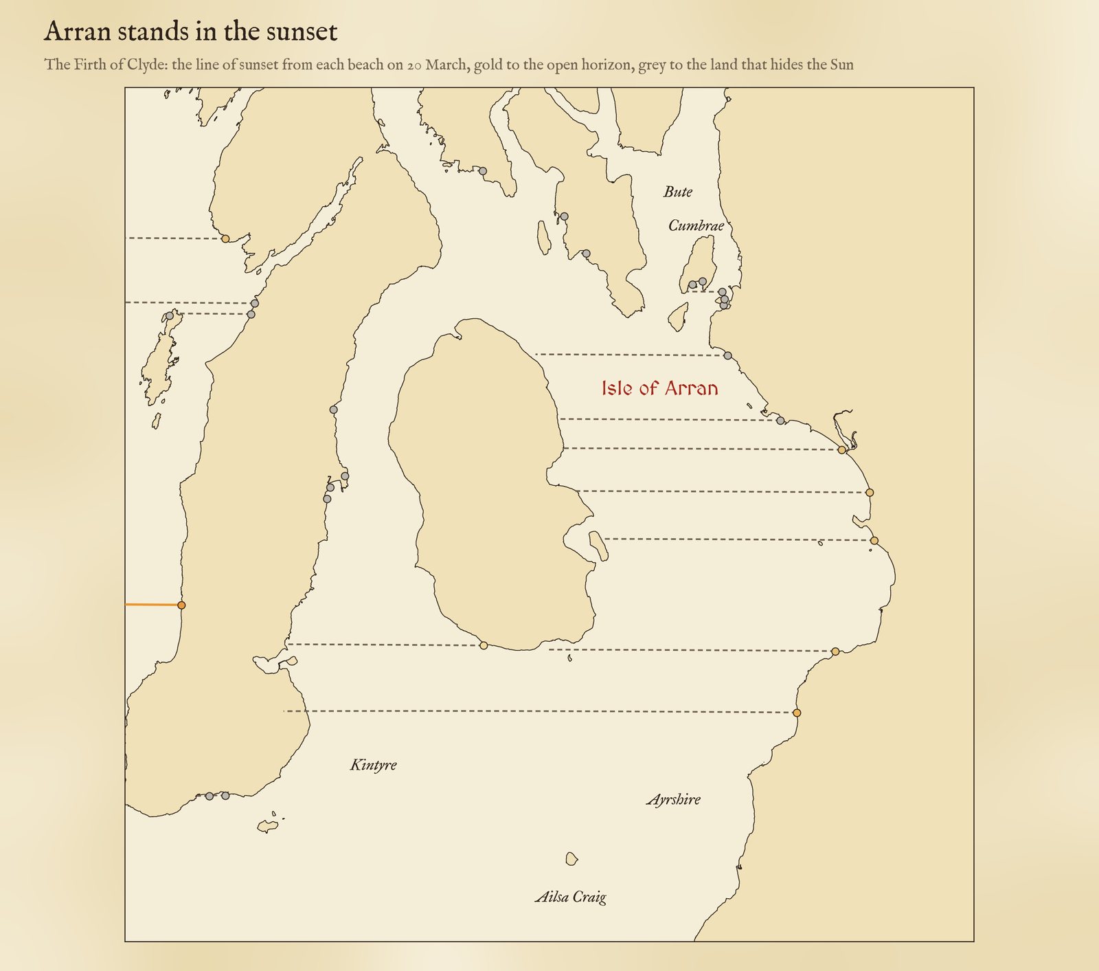
The line of sunset on 20 March from the beaches of the Firth of Clyde.
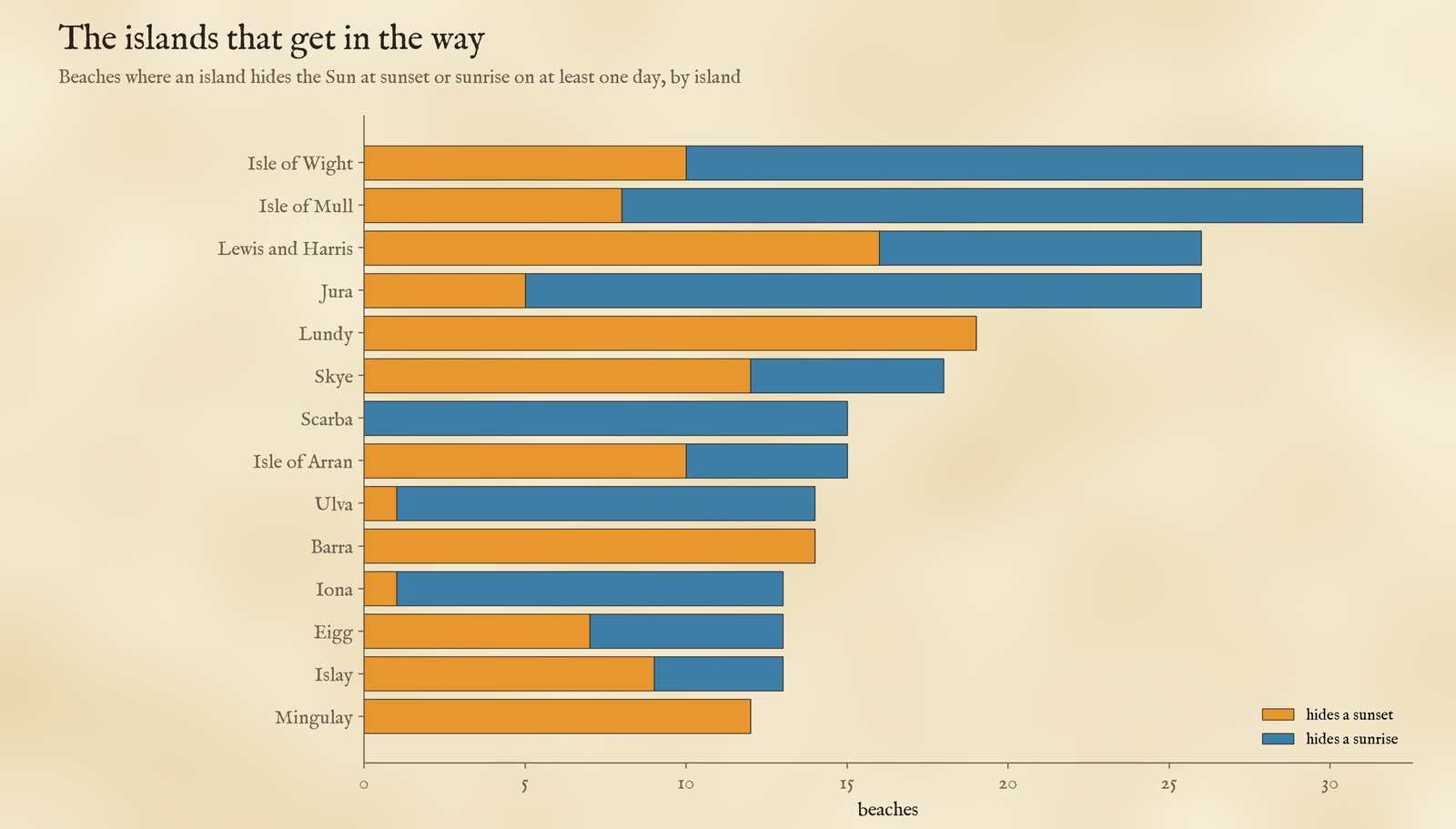
The islands that hide the Sun from the most beaches.
Irish Sea beaches on the English side, like Crosby (262 sea sunsets) and Half Moon Bay at Heysham (215), look west over open water for most of the year. At Crosby the Sun sets behind the Wirral and North Wales in the months around midwinter; at Half Moon Bay it is the other way round, and the summer Sun sets behind the Furness and Cumbrian coast to the north-west. The Isle of Man, over 100 km away, is below the horizon from there. Blackpool's own beach is not among the named beaches in the data.
04 · How I did thisRays across the sea
Beaches. Every beach in OpenStreetMap with a name in the United Kingdom and Ireland, 1,826 pieces merged into 1,768 beaches where pieces of the same name lie within a kilometre. 51 are on lakes or rivers, more than 600 m from the sea, and are left out. For each beach I put an observer at the water's edge, with eyes 3 m above the sea, at whichever point along the beach has the widest view of the year's sunrise and sunset bearings, because you can walk along a beach.
Rays. From that point I cast a ray every quarter of a degree across the bearings where the Sun rises and sets in the year, out to 150 km. For the first 12 km the sea is OpenStreetMap's coastline, from the OpenFreeMap tiles at a resolution of about 20 to 25 m; beyond, land is wherever the AWS terrain tiles are above sea level. A piece of land hides the Sun only if it shows above the sea horizon, allowing for the Earth's curve and the usual bending of light near the ground: low land 50 km away is out of sight (128 m of it is hidden below the horizon), but the mountains of Arran are not. Then for every day of 2026 I worked out the bearing of sunset and sunrise and asked whether its ray reaches open horizon. The islands are named from OpenStreetMap and Natural Earth.
What this cannot say. The weather, mostly. A sea sunset here means a clear line of sight to the sea horizon at the right bearing, not a cloudless evening. The coastline is the line of mean high water, so at low tide in places like Morecambe Bay the "sea" in front of you is sand. Refraction near the horizon varies from night to night, which moves the Sun by up to about half a degree, enough to tip a marginal day either way. Cliffs behind a beach do not matter for a sunset in front of it, but the headlands at its ends do, and from a long beach the answer depends on where you stand; I took the best spot. Only named beaches are mapped.
Sources and licences
- Beaches: © OpenStreetMap contributors (ODbL), queried with QLever.
- Coastline and sea: OpenStreetMap via OpenFreeMap vector tiles (OpenMapTiles schema), release 20261101_080013_pt, zoom 10.
- Terrain: AWS Terrain Tiles, zoom 10. Island outlines and counties: Natural Earth.
- Sun: NOAA solar declination (Spencer 1971 series), standard refraction at the horizon.
- Base map: OpenFreeMap Positron style (OpenStreetMap, ODbL). MapLibre GL JS 4.7.1 (BSD 3-Clause).
- Derived data from OpenStreetMap are under the ODbL; text and figures CC BY 4.0; code MIT.