Book a cheap flight to Frankfurt and you may land at Hahn, 103 km away in the hills of the Hunsrück. Paris Beauvais is 69 km from Paris, Barcelona Reus 88 km from Barcelona and London Oxford Airport 90 km from London. How far can a name stretch? I measured the distance from every airport in Wikidata to the place it is named after, and from every railway station in the UK to the town or village in its name.
01 · AirportsA hundred kilometres from the city on the ticket
Of 4,448 airports with an IATA code that are named after a place, half are within 5.6 km of it and only 3% are more than 30 km away. The far ones are a small and familiar club. The farthest I could confirm is Châlons Vatry in Champagne, marketed as Paris-Vatry, 136 km from Paris. Then come Chicago Rockford (126 km), Frankfurt-Hahn (103 km), Memmingen, which airlines sell as Munich West (101 km), Warsaw Radom (94 km), London Oxford (90 km), Stockholm Skavsta (89 km) and New York Stewart (88 km).
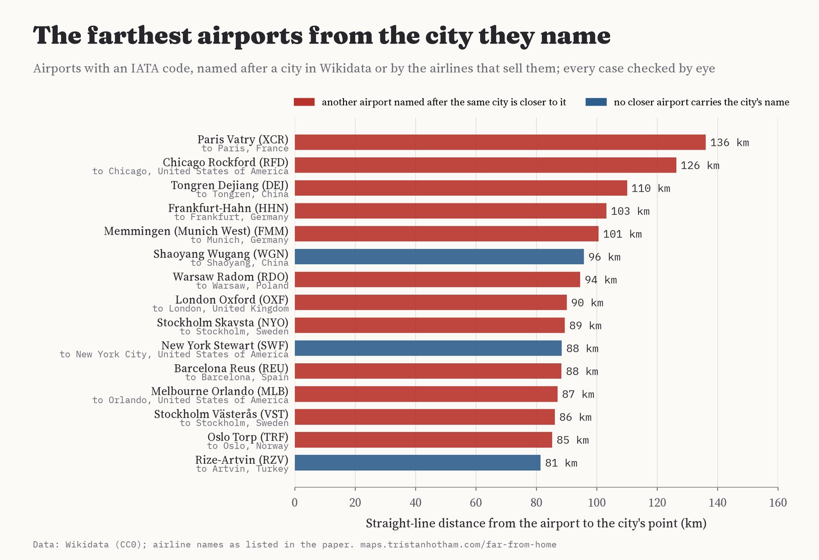
The farthest airports from the city they name, after every case over 40 km was read by eye. Red: another airport named after the same city is closer to it.
Most of these are second airports. In twelve of the top fifteen, another airport named after the same city is closer to it: Skavsta is 11.4 times as far from Stockholm as Bromma, Frankfurt-Hahn 8.8 times as far as Frankfurt's own airport. Several were military fields turned over to the low-cost airlines, who sold them under the name of the big city nearby. In China a different habit stretches names: airports are often named after the prefecture as well as the county they stand in, so Tongren Dejiang is 110 km from Tongren and Shaoyang Wugang 96 km from Shaoyang. Some airports serve two places at once: Rize-Artvin, on Turkey's Black Sea coast, is 81 km from Artvin.
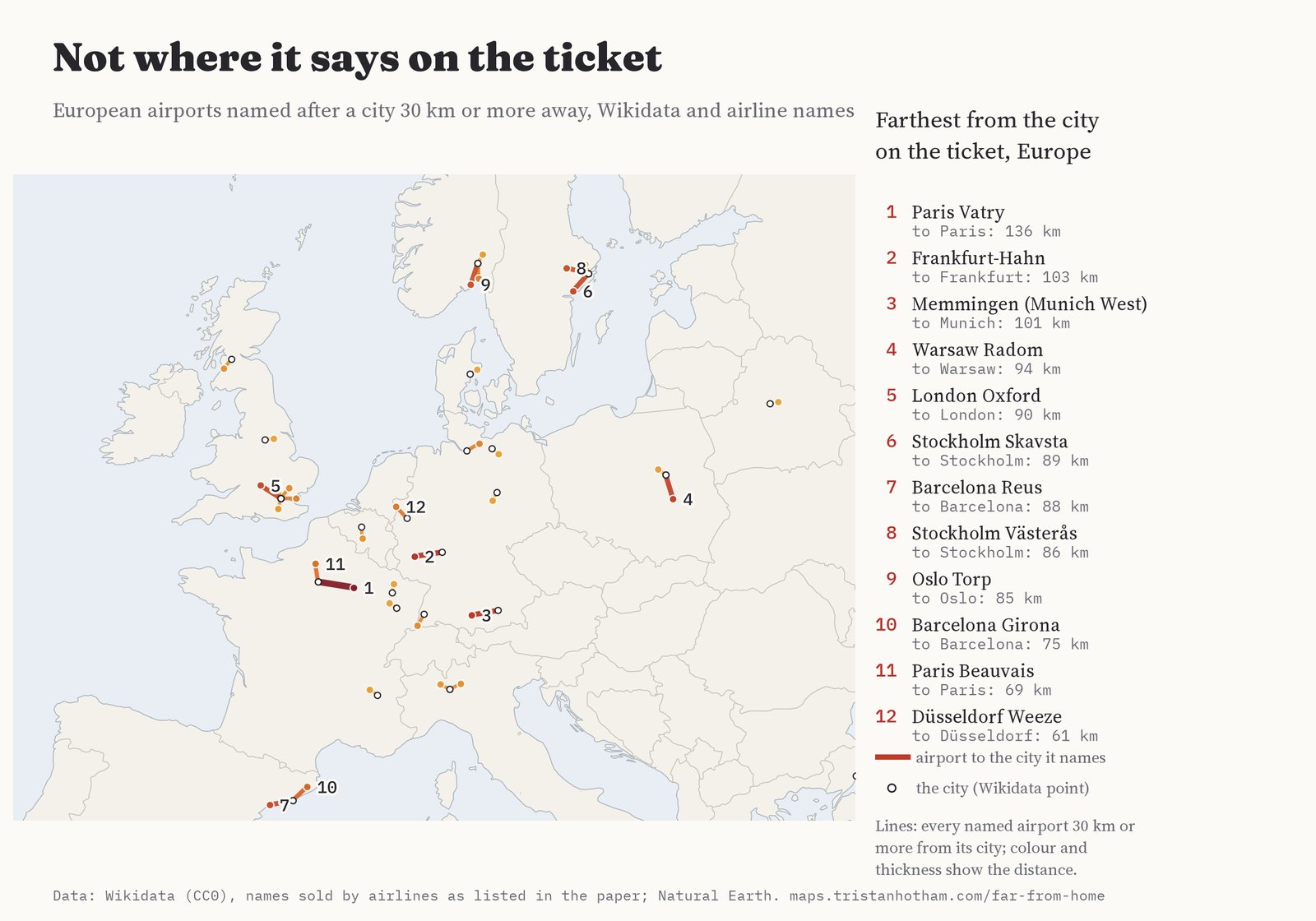
European airports 30 km or more from the city they are named after.
| Airport | Named after | km | Passengers a year* |
|---|---|---|---|
| Paris Vatry (XCR) | Paris | 136 | 132,972 |
| Frankfurt-Hahn (HHN) | Frankfurt | 103 | 1,860,000 |
| Memmingen (Munich West) (FMM) | Munich | 101 | 3,200,000 |
| Warsaw Radom (RDO) | Warsaw | 94 | 9,903 |
| London Oxford (OXF) | London | 90 | 120 |
| Stockholm Skavsta (NYO) | Stockholm | 89 | 555,622 |
| Barcelona Reus (REU) | Barcelona | 88 | 911,827 |
| Stockholm Västerås (VST) | Stockholm | 86 | 93,080 |
| Oslo Torp (TRF) | Oslo | 85 | 2,073,228 |
| Barcelona Girona (GRO) | Barcelona | 75 | 1,313,945 |
| Paris Beauvais (BVA) | Paris | 69 | 4,614,424 |
| Düsseldorf Weeze (NRN) | Düsseldorf | 61 | 1,036,882 |
* The largest annual passenger figure recorded in Wikidata, where there is one. Names in italics are the ones sold by airlines rather than the airport's label in Wikidata. Click a name to see it on the map.
02 · Britain and IrelandLondon is a long way from London Oxford
London has the most stretched names in these islands. London Oxford Airport, at Kidlington, is 90 km from London, London Southend 57 km, Stansted 49 km, Luton 44 km and Gatwick 40 km. Heathrow, at 23 km, is the near one. Outside London the longest stretch is Glasgow Prestwick, 45 km from Glasgow, then Doncaster Sheffield (33 km from Sheffield), which closed in 2022. In the Republic of Ireland every airport is within 8 km of its town, and the ones with broad names are named after a county or a region instead, like Donegal and Connemara, which I left out of the ranking.
| Airport | Named after | km | Passengers a year* |
|---|---|---|---|
| London Oxford (OXF) | London | 90 | 120 |
| London Southend (SEN) | London | 57 | 2,035,535 |
| London Stansted (STN) | London | 49 | 23,319,523 |
| Glasgow Prestwick (PIK) | Glasgow | 45 | 444,433 |
| London Luton (LTN) | London | 44 | 13,322,236 |
| London Gatwick (LGW) | London | 40 | 40,899,000 |
| Doncaster Sheffield (DSA) | Sheffield | 33 | 959,321 |
| London Heathrow (LHR) | London | 23 | 83,884,572 |
03 · StationsRoad, Parkway and Airport
Railway stations hug their towns more tightly. Of 3,576 stations and halts in OpenStreetMap, 2,888 have a name that starts with a town, village or city in Wikidata, and half of those are within 0.6 km of it. Only 169 are 2 km or more away. The farthest are the airport stations: Manchester Airport (12.8 km from Manchester's centre), Birmingham International (12.4 km), London City Airport on the DLR (12.2 km) and Inverness Airport (11.6 km). They are named after the airport rather than the town, so I leave them out of the ranking below. Big cities sprawl, so I also measured how far each station lies beyond a notional circle round its town, sized by its population. On that measure Tiverton Parkway comes first, 9.1 km from Tiverton at Sampford Peverell, then Llanbister Road (6.7 km), Dent (5.8 km), and Beaulieu Road in the New Forest (5.5 km).
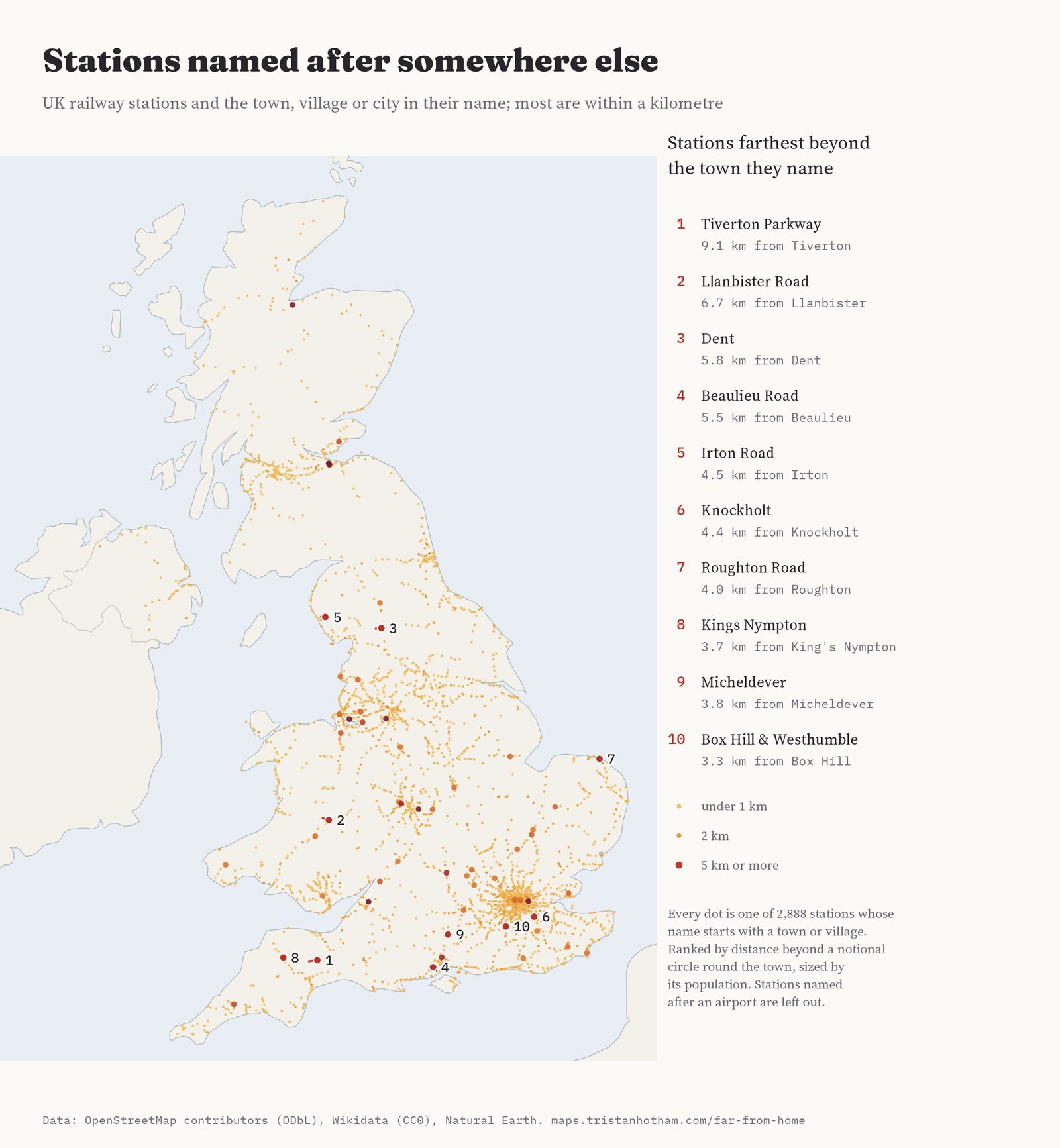
UK stations by distance to the town or village in their name; the ten farthest beyond a notional town circle (airport stations aside) are numbered.
The Victorians had an honest word for a station some way off: Road. Of 82 stations with Road in their name, 62 on the National Rail network, many are named after a street, like Tottenham Court Road or Wandsworth Road. But 9 are named after a village 2 km or more down the road: Llanbister Road, Beaulieu Road, Irton Road on the Ravenglass line, Roughton Road, Wittersham Road, Builth Road for Builth Wells, Clarbeston Road, Farningham Road and Harling Road for East Harling. At Builth Road and Clarbeston Road a new village grew round the station and took its name. The modern word is Parkway: 25 stations, half of them within 2.2 km of their town, though Tiverton Parkway is 9.1 km out and Bristol Parkway 7.7 km.
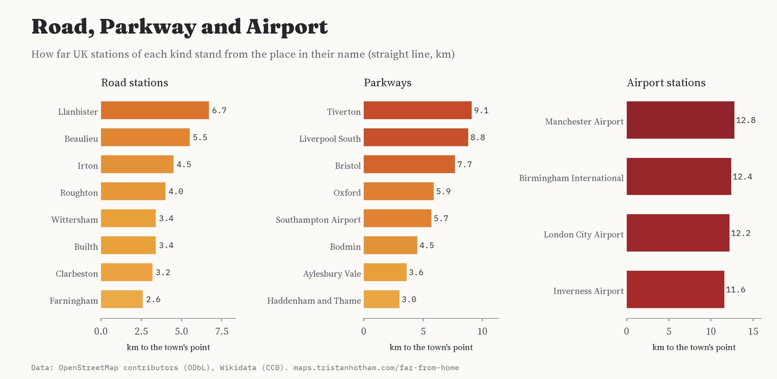
How far stations of each kind stand from the place in their name.
| Station | Named after | km | beyond the town's circle |
|---|---|---|---|
| Tiverton Parkway | Tiverton | 9.1 | 7.6 |
| Llanbister Road | Llanbister | 6.7 | 6.5 |
| Dent | Dent | 5.8 | 5.5 |
| Beaulieu Road | Beaulieu | 5.5 | 5.2 |
| Irton Road | Irton | 4.5 | 4.5 |
| Knockholt | Knockholt | 4.4 | 4.0 |
| Roughton Road | Roughton | 4.0 | 3.6 |
| Kings Nympton | King's Nympton | 3.7 | 3.5 |
| Micheldever | Micheldever | 3.8 | 3.4 |
| Box Hill & Westhumble | Box Hill | 3.3 | 3.3 |
04 · How I did thisNames, points and a lot of checking
Airports. Wikidata lists, for most airports, the places they serve. I kept a place only if the airport is named after it: its name appears in the airport's English label (Basel, Mulhouse and Freiburg all count for the EuroAirport), or it is a town in Natural Earth whose name is in the label and which lies within 150 km, or it is the city that airlines sell the airport under (11 such names, listed in the paper, because Wikidata now labels Hahn simply Hahn Airport). When an airport names several places I rank it by the farthest. Distances are straight lines from the airport's point to the place's point in Wikidata.
Stations. I merged OpenStreetMap station points of the same name within 1 km, split names at "and", "&" and "for", and found the longest run of leading words that is the name of a UK settlement in Wikidata, with short forms (Southend for Southend-on-Sea, Builth for Builth Wells, Harling for East Harling). Each station is measured to the nearest settlement of that name.
Checks. Rankings are where data errors hide, so I read every airport case of 40 km or more (113) and every station match of 3 km or more (286) by eye. Of the airport cases 23 were wrong links or points (Bathurst Island Airfield linked to Bathurst in New South Wales, 3,000 km away; Wilmington, North Carolina, linked to Wilmington, Delaware; two Yichuns, two Nagoyas, two Heringsdorfs), 12 named a region or island, and 12 I could not settle and left out. Of the station matches 208 were a different place of the same name or a feature named like a town, 7 were streets and 7 were points in the wrong place. Every decision is in the overrides files with the data.
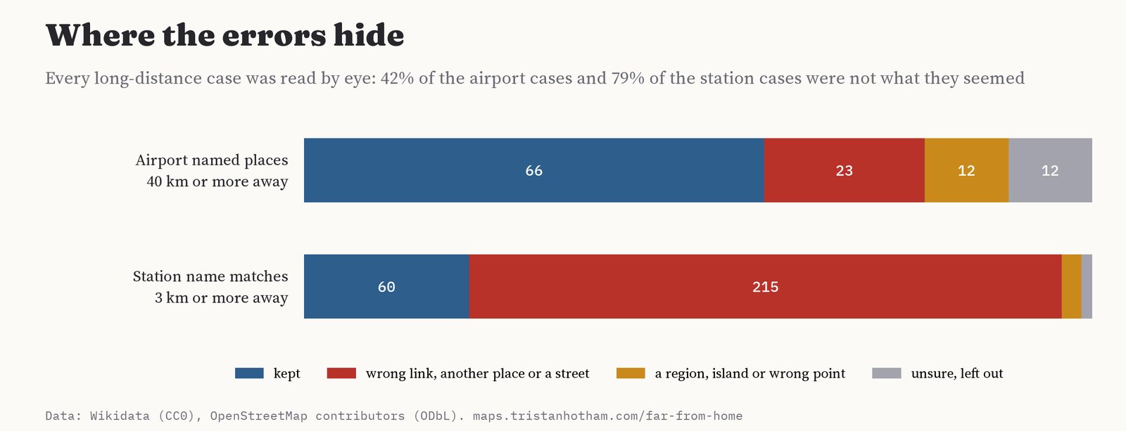
What reading every long case by eye found.
What this cannot say. A straight line is not a journey. A city's point in Wikidata is its centre, not its edge, and population is that of the municipality (Paris is the city of two million, not the region of twelve). Wikidata's list of places served and its settlement list are incomplete: Bradford in West Yorkshire is missing from the settlement list, so its stations go unmatched, and an airport whose city is not linked cannot be measured. Wikidata also keeps closed airports (Oslo Fornebu, Doncaster Sheffield), which can count as the closer airport for a city. Marketing names change, and the ones I used come from my own knowledge of how the airports were sold, checked against airline and airport listings, not from the data.
Sources and licences
- Airports, places served, populations and settlements: Wikidata (CC0), queried with QLever, 2026.
- Stations: © OpenStreetMap contributors (ODbL), railway=station and railway=halt in the UK, 2026.
- Countries and towns: Natural Earth (public domain).
- Base map: OpenFreeMap Positron style, from OpenStreetMap vector tiles (ODbL). MapLibre GL JS 4.7.1 (BSD 3-Clause).
- Derived station data are under the ODbL; airport data CC0; text and figures CC BY 4.0; code MIT.