Stand in almost any old English parish church and you face east, towards the altar, Jerusalem and the rising sun. But not exactly east. Some naves swing north, some south, by a few degrees or by twenty. For more than a century people have offered an explanation: the builders pegged out the line on the morning of the patron saint's day, and aimed it at the sunrise. A church of St John the Baptist, whose feast is at midsummer, should then point well north of east, and a church of St Nicholas, in December, well south.
So I measured them. OpenStreetMap has the outline of 40,636 church buildings in the United Kingdom. For the 32,007 that are clearly longer than they are wide, I took the long axis of the smallest rectangle that fits round the footprint and worked out how far it turns from true east. Wikidata adds the patron saint, the date and the listing for many of them.
01 · East, mostlyOld churches face east; new ones face the street
Of all 32,007 measured churches, 30% lie within 10° of due east and 26% are closer to north and south than to east and west. But age changes everything. Among the historic parish churches (those dated before 1540, or, when undated, listed Grade I or II* or category A, of the established churches or untagged), 54% lie within 10° of east and only 1.7% turn more than 45°. Churches dated 1800 to 1913 manage 25%, and those from 1914 onwards 20%. Methodist, Baptist and other Free Church chapels, which never held to the rule, manage 14%, little better than the 11.1% that a random direction would give.
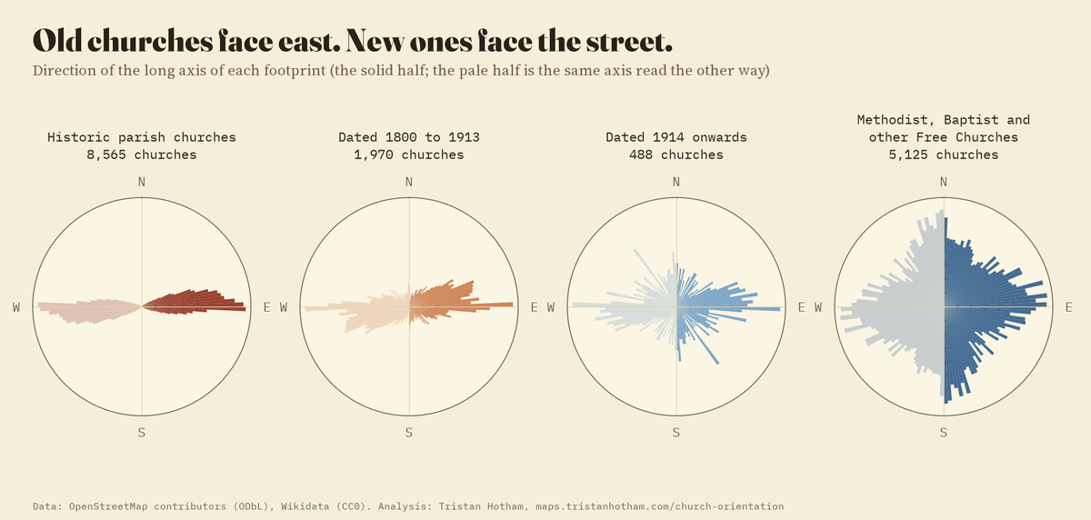
The long axis of each footprint. Historic parish churches cluster on east; later churches and chapels point every way.
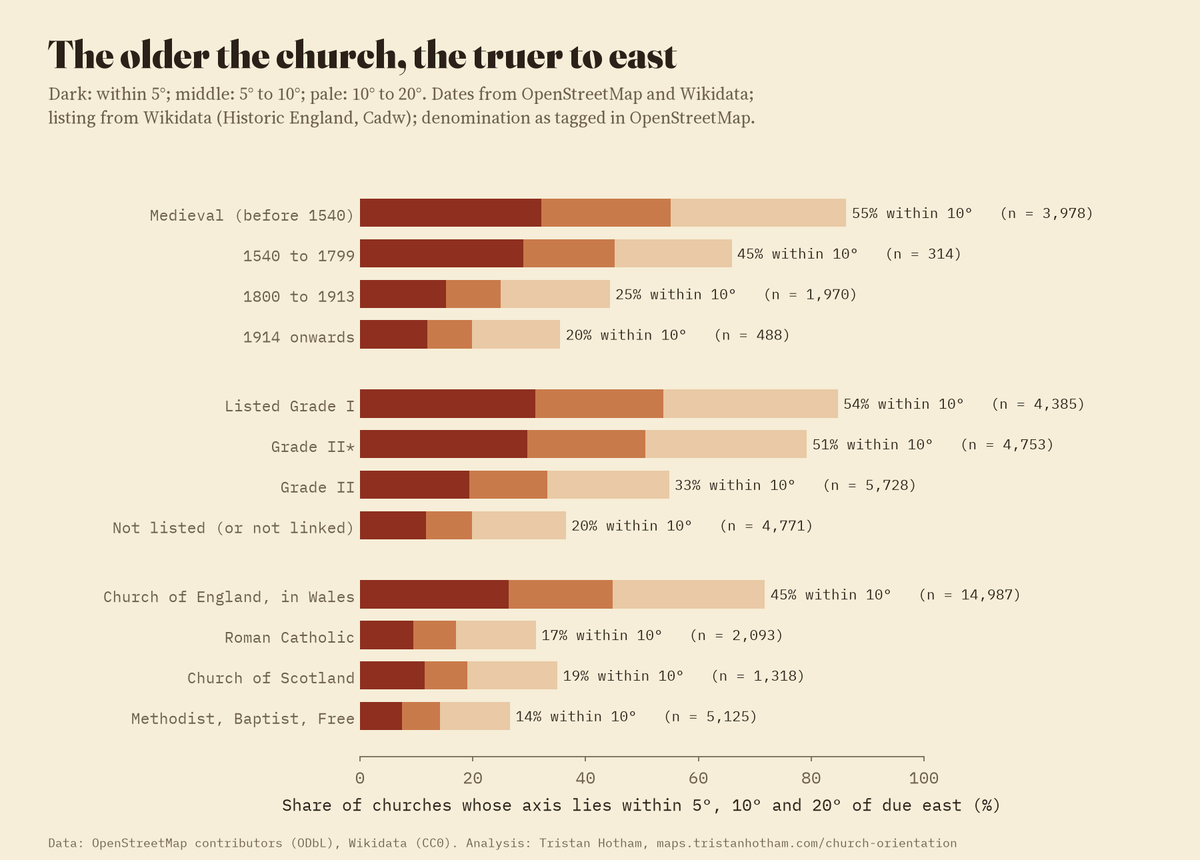
Share within 5°, 10° and 20° of due east, by date, listing and denomination.
02 · The saint's dayMidsummer saints face the same way as midwinter saints
If churches were set out on the patron saint's day, the saint would predict the axis. It does not. I worked out the sunrise direction over a flat horizon for each church's latitude on its saint's feast, moving medieval dates to the Julian calendar of the time (seven to ten days later in the sun's year). The historic churches of John the Baptist, Peter and the other midsummer saints point on average at 85.5° from north, where the feast-day sunrise would be 51°. The churches of Nicholas, Thomas, Andrew and the other midwinter saints point at 85.4°, where the sunrise would be 129°. Across 32 saints with 25 or more historic churches, the feast-day sunrise spans 80°, the average axes only 8°.
A sharper test shuffles the saints among the churches at random, 10,000 times, and asks whether the real saints fit the axes better than shuffled ones. They do not: the real saints miss by 30.9° on average, the shuffled ones by 30.9° (p = 0.54). Just 3.1% of historic churches lie within 3° of their feast-day sunrise, against 3.2% by chance. Mary, the commonest dedication, has four feasts. Her historic churches average 85.1°, the same as everyone else's, which happens to lie near the sunrise of her March and September feasts and far from her February and August ones. The idea is not new to be doubted: Ian Hinton found the same for about 1,500 rural churches in 2006. The map shows the predicted sunrise as a dashed line beside every church when you zoom in, so you can check your own.
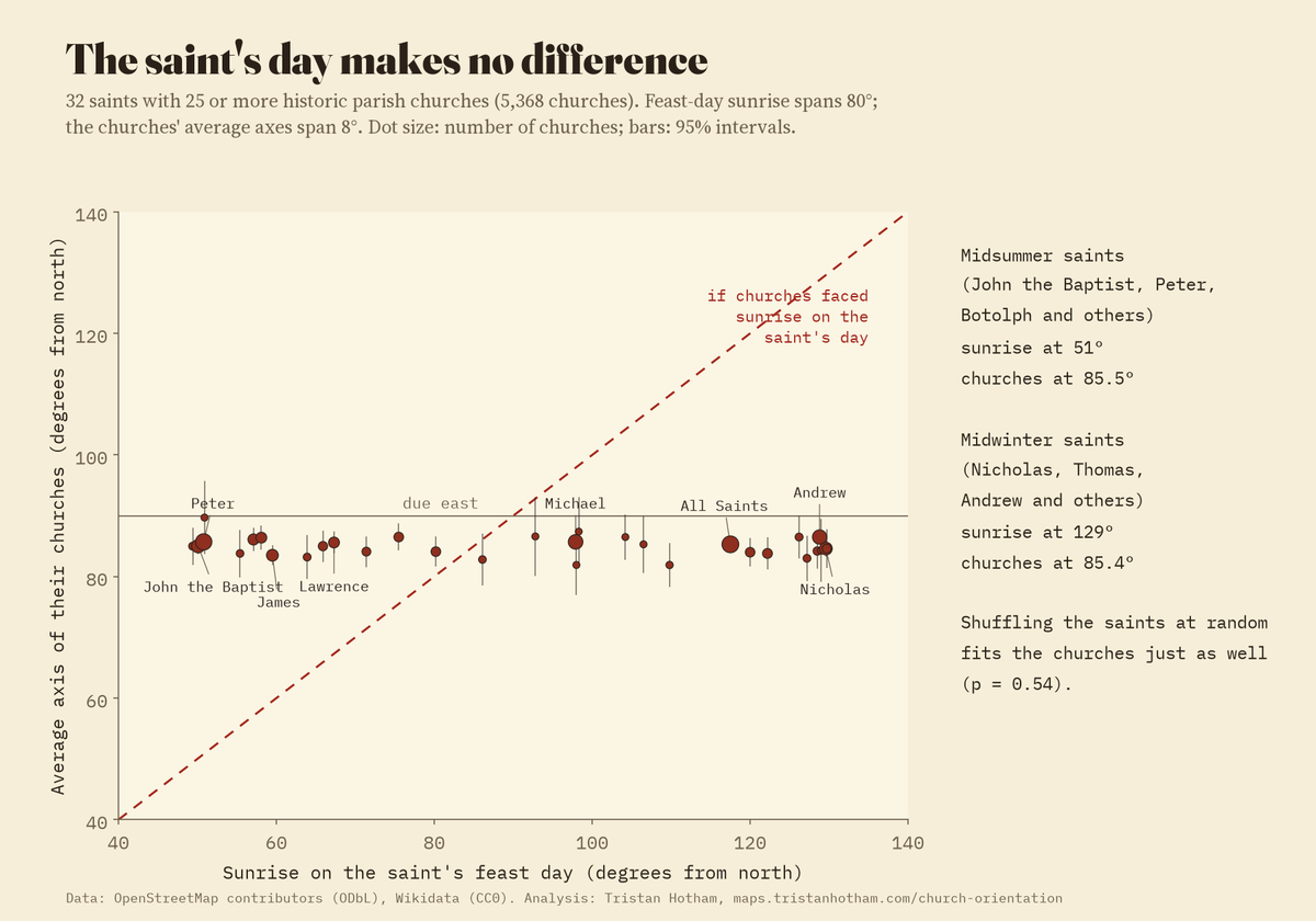
Each dot is a saint. If churches faced the feast-day sunrise the dots would lie on the dashed line; they lie flat.
03 · North of eastA small, steady lean, stronger in the west
What the old churches do share is a lean. 65% of historic churches within 45° of east turn north of it, on average by 4.9°, so the average axis points at 85.1° rather than 90°. The lean grows from east to west: east of 1°E, mostly Norfolk, Suffolk and east Kent, the historic churches average 0.3°, true east to within a whisker, while those west of 3°W turn 6.3° north on average. That fits a sunrise a little north of the equinox, the spring or Easter sun, or simply a habit of setting out by eye that drifted from place to place. The data cannot tell those apart.
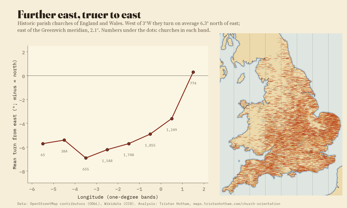
Mean turn from east of historic parish churches in England and Wales, by one-degree band of longitude.
04 · The streetIn towns, the grid often wins
For a random sample of 5,967 churches I read the roads within 150 m from OpenFreeMap's vector tiles and found the main direction of the local street grid. In towns (at least 2,000 m of road inside that circle), where the grid runs well off east, 85% of churches dated 1800 onwards line up closer to the streets than to east, and 90% of Roman Catholic and Free Church buildings. For historic parish churches in towns it is 59%, from a small sample. The arrow runs both ways: a Victorian church was fitted into a plot on a street that was already there, while the lanes round a medieval church were often laid out along its churchyard, which is why even country churches share a direction with their nearest roads more often than not (62%).
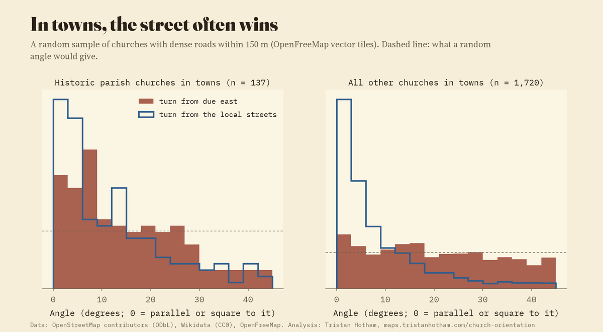
Angle between each town church and due east (bars), and between it and the local street grid (line).
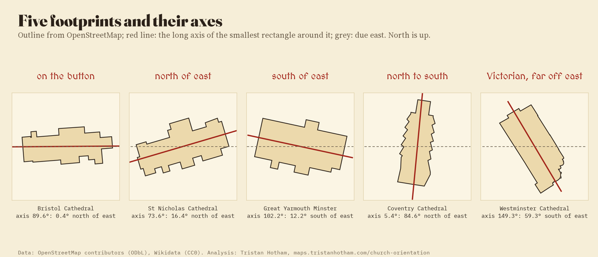
Five footprints and their measured axes, from OpenStreetMap.
05 · How I made thisMeasuring a building's axis
Footprints. All buildings tagged as a church, cathedral or chapel in OpenStreetMap for the United Kingdom, plus places of worship of the Christian religion drawn as other buildings, 40,636 outlines in all; points are left out because they have no shape. Each outline is laid flat around its own centre with north kept true, and the long side of the smallest rectangle that fits round it gives the axis, read as the east end. I kept those at least 1.3 times as long as wide and between 60 and 8,000 square metres: 32,007. A second method, the length-weighted direction of the walls, agrees within 2° for 91% of them.
Saints, dates and listing. Wikidata items were joined to 21,956 footprints through the OpenStreetMap wikidata tag, the OSM way id in Wikidata, or the item's coordinates lying in the footprint. The saint comes from Wikidata's dedication, else from the church's name, read with the parser from my saints-geography study. Dates are the earliest of the OpenStreetMap start date and the Wikidata inception, and are known for 6,750 churches.
What it cannot say. A footprint is not a nave: towers, aisles, transepts and later additions bend the rectangle, though for most churches the nave dominates. Wikidata inception is sometimes the founding of the parish rather than the standing building. Feast dates follow the usual calendars, but a church may have changed its dedication, and many saints have more than one feast. The horizon is taken as flat, so hills that delay the sunrise are ignored. The street test uses today's streets. None of this explains a lean of a few degrees; it only shows what does not.
Saint by saint: historic parish churches
Earlier work
- Ali, J. R. and Cunich, P. (2001) The orientation of churches: some new evidence. The Antiquaries Journal 81, 155 to 193. They measured 143 major churches of about 1050 to 1200 and found the patron saint's sunrise could explain up to 43% if sunrise and sunset are both allowed.
- Hinton, I. (2006) Church alignment and patronal saint's days. The Antiquaries Journal 86, 206 to 226. About 1,500 rural churches; churches of summer and winter saints face the same way.
- Furuhashi, T. and Terado, H. (2026) Between sacred tradition and urban form: an OpenStreetMap-based analysis of church orientation patterns in Milan. ISPRS Archives L-4/W1-2026, 43 to 48 (FOSS4G 2026).
Sources and licences
- Church footprints, names, denominations and dates: © OpenStreetMap contributors, Open Database Licence, queried through QLever. The derived church table is under the ODbL.
- Saints, inception dates and listing grades: Wikidata (CC0), from Historic England, Cadw, Historic Environment Scotland and the Department for Communities NI records.
- Dedication parser: saints-geography (MIT). Street grid: OpenFreeMap vector tiles (OpenMapTiles schema, OpenStreetMap data).
- Map: OpenStreetMap contributors (ODbL), vector tiles by OpenFreeMap; the Inked World map style and its data (Natural Earth, RESOLVE Ecoregions 2017 CC BY 4.0, Wikidata CC0), from the ink-map study; elevation from AWS Terrain Tiles.
- Fonts: MedievalSharp and the IM Fell types (SIL Open Font License). MapLibre GL JS 4.7.1 (BSD 3-Clause).